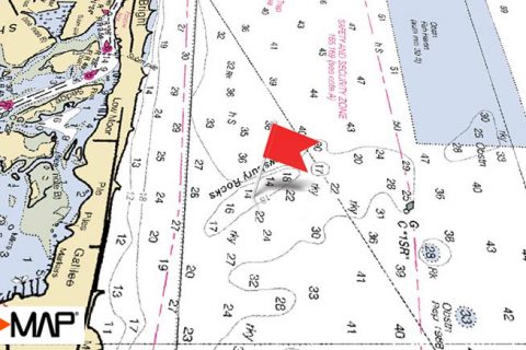
An Oasis For Marine Life

Shrewsbury Rocks are a natural rock formation off Monmouth Beach, New Jersey. This line of greensand rocks act as an oasis for marine life in the relatively featureless stretch of water between Sandy Hook and Shark River Inlet. A wide variety of fish can be caught at the Shrewsbury Rocks throughout the year.
Bottom-Fishing at Shrewsbury Rocks

In the cool months, fishing effort around Shrewsbury Rocks is focused on blackfish. Target the shallower areas of the rocks early in the season (A), and move off to the deeper end as water temperatures drop (B).
Fluke make a home at the Shrewsbury Rocks during the summer. They will sit on the sandy areas near the rocks feeding on crabs, bergalls and other baitfish that live in the structure. Use your chartplotter to make short drifts over areas among the rough bottom where you can find fluke and avoid donating your rigs. The area east of the Shrewsbury Rocks out by the 3-mile line, known as the Rattlesnake (C), is a popular fluke fishing spot in the summer.

Plan your trips around the tides to make sure that you have good conditions for drifting for fluke. C-MAP charts allow you forecast tides so you can look ahead to a potential fishing date and decide what time you need to be on the water.
Stripers and Blues at Shrewsbury Rocks
In the spring, the current breaks created by the rocks serve as a feeding ground for striped bass as they move north. Some stripers will remain at Shrewsbury Rocks through the summer, providing early bird anglers with opportunities to catch first light bass even in the dog days of August. In the fall, the Shrewsbury Rocks are once again a staging area for migrating stripers.

On June days when striped bass aren’t harassing the schools of bunker swimming off the Monmouth County beaches, many fishermen will fill their livewells with the baitfish and motor them to the Shrewsbury Rocks. During the spring run, stripers almost always seem to be hanging around the rocks, and a live bunker or chunk drifted by the inshore side of the structure is rarely refused (D).

Trolling around the rocks is another popular tactic, particularly in the fall when stripers and blues loosely associate with the structure as they feed on the schooling baitfish trying to make their way south.
Big bluefish hunt the waters around Shrewsbury Rocks all summer long. On some days, topwaters ripped across the surface will trigger savage strikes from the monster blues.
Late summer and early fall can even bring some blitzing false albacore to the Shrewsbury Rocks.
Love to know where the fish are.
Congratulations on the release more people should be doing the same
Very helpful information!!!!
Compass reading to hot spots from sandy hook