
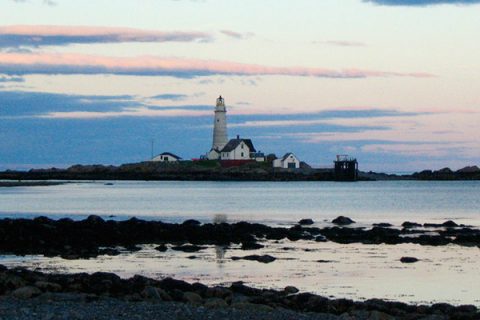
Arrive by kayak, boat or ferry and explore the history and fantastic fishing of the Boston Harbor Islands.
Within sight of the skyline of the largest city in New England lie 34 islands and peninsulas spread over 50 square miles of Boston Harbor waters. For residents of the densely populated metropolitan Boston area, they offer a unique recreational resource and a rare sense of isolation. For the finned residents of the Harbor – striped bass, bluefish, flounder and more – they offer submerged rocks, boulder fields and big ledges, sandy stretches, deep coves, sprawling flats, and fast tidal rips.

While most visitors to the Boston Harbor Islands are day-trippers, there are five islands that offer overnight camping options. A combination camping and fishing trip is perfect for fishermen who know that the best fishing is often before sunrise and after sunset, and for anglers who want a little more time to explore the wealth of structure around the islands.
The Harbor Islands have an advantage over all of the other Massachusetts saltwater camping islands: regularly-scheduled ferry service on large, efficient boats. Island shuttle service leaves from numerous locations between Boston and the South Shore: from downtown Boston at Long Wharf, Quincy’s Fore River Shipyard, Shipyard Pier in Hingham, and Pemberton Point in Hull. And if you’re a boater who wants to camp on the islands, there are five trailer ramps: Shirley Street, Winthrop; Morrissey Boulevard, Dorchester at the Corita gas tank; Bayview Ave., Quincy; Beach Road, Winthrop; and Main Street, Hull.

The inner harbor’s camping islands – Bumpkin, Grape and Peddocks – all lie within easy paddling distance of the South Shore towns of Hull, Hingham and Quincy and can be reached in recreational sit-on-top kayaks. Reaching the more remote, raw and exposed outer islands – Lovells and Great Brewster – requires a touring-style sea kayak and an experienced paddler to lead the expedition.
You have to be fully self-sufficient to camp on the Harbor Islands. Bring everything you need: tent, sleeping bag, flashlights, food, drinking water, ice, cooler, etc. And don’t forget your fishing gear. It can be a bit of a challenge to pack everything in a kayak, but taking the time to load all the necessary gear will be worth it.
CAMPING: Overnight camping is permitted only on designated islands. Camping is by reservation only and a fee is charged. To reserve campsites call 1-877-422-6762 or reserve on the web at www.reserveamerica.com.
TRASH: Visitors to all the harbor islands must use a carry in, carry out policy. There are no trash receptacles on the harbor islands.
FOOD: Picnic tables and small charcoal grills are available on a first come first served basis on Bumpkin, Grape, Lovells and Peddocks islands.
WATER: Potable water is available on Georges and Peddocks islands. There is no water on Grape, Bumpkin, Great Brewster and Lovells.
REST ROOMS: There are restroom facilities on Spectacle and Georges Island. Grape, Bumpkin, Lovells and Peddocks have composting toilets only.
PRIVATE BOATERS: Limited docking space is available at Georges Island on a first-come, first-served basis. The marina on Spectacle Island is a fee-based docking facility. On all islands, designated dock space is available for drop off and pick up only. A small self-serve dinghy is available for rowing to and from anchorage areas. Kayak beach landings and small motorboat beach anchoring is welcome. A limited number of mooring balls are available along Georges, Peddocks and other Boston Harbor Islands.
FERRY SERVICE: For schedules, please call (617) 223 8666, or go to bostonharborislands.org.

Tucked away in southwest Hull Bay and situated just a few hundred yards from the mainland at aptly-named Sunset Point, Bumpkin is a good choice for first-time kayak campers or for powerboat fishermen planning to camp and fish with kids. The fishing is good, and the island lies close enough to the mainland that you can easily head back home if the weather turns foul or you discover that sleeping on hard ground isn’t your cup of tea. Hull’s shoreline lies a reassuring quarter of a mile away. In fact, on low tides, the flat at White Head connects Bumpkin to Hull.
The fishing in the immediate vicinity – all of Hull Bay and Bumpkin’s own perimeter – is reliable for smaller striped bass and bluefish. The calm waters, protected from wind, waves and swell, will appeal to the fly-fisherman, the light-tackle enthusiast, and the kayak fisherman or powerboater not completely confident in open-water boat handling. Bumpkin’s waters offer depths mostly less than 10 feet at low tide. Good spots include the sprawling Crow Point Flats southwest of the island and the shallows of nearby Hingham Bay. Use light spinning gear to toss plugs, jigs or poppers to peck at the flats and boulder fields at nearby Worlds End. Head west to the waters of Nut Island, Piglet Rocks, and the shallows at the mouth of the Weymouth Fore River. Hold in an eddy to work the current seams of the fast tidal flows at narrow West Gut.
If you want to stick close to the island, concentrate your efforts on the extensive flats that lie adjacent to the island. Cut by deep channels, the flats and the channels hold stripers over 28 inches. The bottom is dark mud, but there are still opportunities to sight-fish to lunkers, especially during the fall run, when keepers cruise the flats in search of forage.
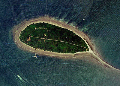
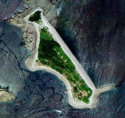
Bumpkin itself is small and flat, covering just 35 acres. There are plenty of hiking trails. The island’s shoreline is made up mostly of slate-and-shale beaches. You’ll find the ruins of an old hospital on the island’s north side. In short, Bumpkin, like all the Boston Harbor islands, is more than just a fishing destination. Land, set up camp, and simply hike around or relax if fishing isn’t on your agenda.
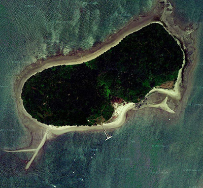
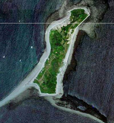
Grape Island, just a mile southwest of Bumpkin, offers similar fishing. There are nearby flats and channels, and there is easy access via Weymouth Fore River Channel to Nantasket Roads and the wilds of outer Boston Harbor. Grape features the same double-drumlin topography of so many of the Boston Harbor islands: two steep hills giving way to flat isthmuses that form gravel or slate beaches. Grape lies close to the busy neighborhoods and boat channels of Weymouth. Webb Park, a scant 300 yards from Grape, acts as a noise buffer. Covering 50 acres and with a fine summit view from its 70-foot drumlin, camping at Grape is pretty similar to Bumpkin; choose one as a base to explore the other.
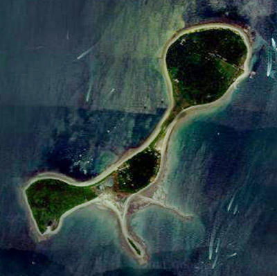
Peddocks Island is much more than a place to simply camp and fish, it’s also a place to explore for an entire day; the good fishing is simply a bonus. A mile long and richly varied in its topography, from open fields to rocky headlands and wooded groves, Peddocks is dotted by a small summer cottage village and crossed by rough asphalt roads connecting a haunted ghost town of abandoned WWII military barracks, gun emplacements and officers’ quarters.
For kayak fishermen, the most direct route is to launch from Windmill Point in Hull and paddle an easy-looking eighth of a mile to the island’s shore, but appearances can be deceiving: that eighth of a mile can prove to be the longest trip of your life. The tides in Hull Gut run hard. In northerly and southerly winds, the Gut’s wind-driven chop can run steep enough to swamp a sit-in kayak. Moreover, powerboat traffic in the Gut, which provides the major gateway between Quincy, Hull, Weymouth and Hingham bays and Nantasket Roads, can be thick. Pick a calm day on a slack tide if you are unsure of your skills, and the paddle to the island will take all of 15 minutes.
When you arrive on the island, you will likely be tempted to put away the fishing gear and spend a lot of time exploring the island on foot. Kids will be entranced by the spooky atmosphere of the island; its interior turns dark and mysterious at midday due to the dense groves of trees. Wander around long enough and inevitably you’ll stumble upon the mysterious clusters of abandoned barracks. There’s also plenty of natural beauty here, all within view of the distant Boston skyline: Perry Cove to the north, Portuguese Cove to the west, and the lengthy shale beach that connects them. These are wonderfully sunlit places to wander into after tramping around in the dark woods.
The fishing advantages quickly add up here. The inner harbor’s flats lie to east, west and south. Pay close attention to the open beaches on either side of the spit that connects to the two hilly ends of the island, and to the rocky, heavily structured shoreline of the island itself. Peddocks is surrounded by extensive drop-offs, 6-foot shallows adjacent to 30 feet of water. The perimeter and structure presents excellent trolling. Likewise, you’ll find excellent plugging and fly-fishing in the island’s half-dozen coves.
The coves at Harrys Rock and Prince Head on the island’s south side are excellent spots, and the fast tidal flow at Hull Gut, adjacent to the island’s popular camping area and busy public pier, will give up big striped bass to surfcasters. Once you’ve fished the island, you can always shoot through the Gut for the Outer Harbor islands, just 10 minutes away via powerboat.
Peddocks Island is currently undergoing renovations, and camping areas are expected to reopen by late summer 2012. Check with the Massachusetts Department of Conservation and Recreation for updates.
Venturing to Lovells and Great Brewster to camp and fish their shores is more of a wilderness camping experience. Fishing can seem less the main purpose, and more of a diversion. You are in an island archipelago that lies adjacent to open water, potentially big swell and waves, and high winds. There is no reassuring mainland nearby to glance at, no bright cluster of shoreline lights, no hum of trucks or cars onshore to remind you where the rest of the world lies. While the fishing can be excellent, sometimes the fish can strike you as an afterthought when faced with the islands’ strange air of isolation.
Great Brewster Island is the more remote of the two outer harbor islands. Unlike Lovells, which lies close to Georges (where day-trippers flock via ferry to explore the Civil War-era tunnels, gun emplacements, barracks and grounds of Fort Warren), Great Brewster isn’t served by ferry or shuttle service. Your only choice is a long paddle in a fast kayak (boats shorter than 16 feet are not recommended) or a powerboat. There is no pier on Great Brewster Island. Approach this island with caution. Visitor facilities are limited to a composting toilet and wild paths. Limited capacity outback camping permits are available by calling the park office at 781-740-1605 x205.

A long gravel bar, heavy with glacial till, connects the southeast tip of the island at low tide to nearby Little Brewster, home of Boston Light, where you can land and explore. At the north end of the island, a massive sand and dirt drumlin soars 103 feet into the air, rising from the near-sea-level tent sites like an abandoned ski slope. Climb the drumlin and you hike a steep grade dense with trees and brush and startling glimpses of the bricked-over entrances to the island’s hidden tunnels and bunkers. And then you get the view – all of Boston, most of the North Shore, a good piece of the South Shore, and the remainder of the outer harbor islands. Make your way carefully to the western of the drumlin’s summit, hold on to your hat, and peer over the edge of a sheer, cleaved-off mud cliff showing in raw detail what the island is made of: wet, crumbling slabs of clay, stones, rocks, and sand from which ventilation pipes from the island’s bunkers stick out.
Camping on Great Brewster takes work. Land on the island’s sheltered west side to access the campground. The beach is a rocky cobble, the steep berm is loose, and at low tide, the footing is slick. Haul your camping gear the 50 yards or so inland to the campground and you’ll find a fire pit or two, a couple forlorn-looking picnic tables, and not much else. The esker just beyond the tent sites camouflages the cemented-over entrance to an abandoned bunker and provides good cover from wind. The island sees little upkeep and gets scant attention from cleanup crews. You are roughing it as coarsely as any backpacker about to put down stakes for the night along the Appalachian Trail, but your access to the outer harbor’s waters is immediate. Look for Martin and Boston ledges to the northeast, and Ram Head Flats to the east side of Lovells. Troll or chum-and-chunk by boat, cast or jig from the shoreline or fly-cast the flats. You will find plenty of keeper bass and large ocean-going bluefish in the 30-inch-plus range.
Lovells Island has ample camping sites and plenty of raw, untended acreage to wander around in after you set up camp. You’ll find the remnants of Fort Standish and its massive big-gun bunkers built to accommodate swiveling batteries meant to pound Boston-bound warships. The site will enthrall kids. Sprawling mud flats lie off the northwest side of the island at Ram Head. Excellent for close-shore sight-fishing and fly-fishing at mid-tide, the flats transform the island’s 62 heavily vegetated acres into a varied 120-acre ecosystem of intertidal zones, shale-and-sand beaches and thick, heavy goop.
Lovells is a comfortable boat-camping destination. The camping grounds are soft and flat, well protected from north winds by thick groves of trees and a long, high dune thick with beach grass. The topography is a mixture of sand, rocks, boulders, till and mud. The island’s contours are subtle: three round drumlins connected to one another by a saltmarsh and a flat, low field. Motor to the southeast end the island and you are a short distance from the stark and windswept open wilds of Outer Boston Harbor: the haunted-looking Brewsters, formidable Graves and Shag Rocks, the Roaring Bulls, narrow Hypocrite Channel – all excellent fishing grounds. The waters out here are prime chunking, drift-fishing and tube-and-worm territory. Shallow ledges lie adjacent to 60- to 80-foot depths. The waters are rough and turbulent when the wind is up and heave violently in any kind of groundswell. Focus your fishing efforts along the edges of the submerged ledges or within the confines of the narrow channels. The islands are heavily structured with boulder fields, mussel beds and countless coves.
Shallow waters with numerous abrupt drop-offs form good structure along the east side of the island, especially near the exposed rocks off green can #11 at Ram Head’s northernmost mud bar. Sheltered mud flats extend for nearly three-quarters of a mile from the island before they meet up with the edge of the South Channel shipping lane and the deep water surrounding several submerged ledges about a half-mile north. Fish the shallows and the steep shale-and-sand beach off the northeast side of the island with Kastmasters and swimming plugs. When you fish the deeper water, switch to bait and heavier gear to plumb the ledges.
Pay close attention to Black Rock Channel at the south end of the island. Likewise, make a deliberate effort to fish the waters due east of Lovells where Great Brewster Spit, a mile-long gravel bar, rises at low tide and comes close to connecting Lovells to Great Brewster Island. Look for red nun 2B on the north side of Black Rock Channel. The 4-foot shallows drop away abruptly to form a narrow 27-foot-deep channel. Large bass hold here during the late spring and early fall, attracted by the tidal currents on the west side of the island and the baitfish-rich flats of the northeast side.
As for Lovells itself, you’ve got plenty of methods and spots to choose from, each as productive as the next. As good a place as any is the fast tidal channel just a stone’s throw off the dock on the southwest shore of the island. The Narrows, as the channel is called, runs from Lovells to nearby Gallops and Georges islands. Barely an eighth of a mile wide, the channel is deep. A good tactic is to set up in the eddy off Gallops Island’s east end, by the riprap supporting 29-foot high 4-second flashing green fixed light number 7. Hold in the eddy and toss heavy jigs upcurrent. Give the jig time to sink, then retrieve it with slow, repeated hops. Large keepers hold near the bottom. If you’re a bait fisherman, cast chunks of mackerel or sea herring on unweighted hooks upcurrent, let the bait sink, then tease it across the current.
While you fish, take a moment to consider an oddity of military history. A Civil War era tunnel once lay in the mud below The Narrows. The plan was to fill it with explosives, to detonate if a warship tried to slink through to harass Quincy or Dorchester. Even if the fishing is slow, there’s plenty to occupy your imagination when spending time on the Boston Harbor Islands.
For the adventuresome kayak fisherman paddling a long, fast sea boat (16-foot-plus, with a fully enclosed cockpit, watertight bulkheads and hatches), camp fishing Boston Harbor’s outer islands is an expedition of the finest sort. Unless you get shuttled there by powerboat, neither island is appropriate for the sit-on-top kayaker in a 10- to 13-foot boat. To reach the outer harbor islands, you have to paddle significant distances across numerous shipping lanes and wide stretches of open water. The rewards, however, are significant. The seasoned sea-kayak fisherman who camps and fishes the outer harbor islands will have a true adventure: the islands are remote, severe in their isolation, and fully exposed to wind and weather.
There are two classic routes for long-distance paddlers. Launch from Deer Island/Yerrel Beach at Winthrop and head to Great Brewster, a three-mile trip that includes running past the famed Faun Bar and the Deer Island Rip. Or, head first for spectacular Graves Light, then backtrack to Great Brewster via Green, Calf, Little Calf, Middle, Outer and Little Brewster islands. Stripers in these waters are big, and so is the east-running swell if the wind is up.
Take great care crossing the no-nonsense shipping lanes of the North and South channels. The caution is as applicable to powerboat fishermen as it is to kayak fishermen. The channels see every type of oceangoing traffic: towering oil tankers, slab-sided container ships whose passing casts huge shadows, ten-story-high cruise ships gliding past like floating apartment buildings, burly ocean-going tugs, menacing-looking NATO warships and fast-moving Homeland Security gunboats. When in doubt, broadcast your channel transit on VHF channel 13. You’ll hear back, and pronto, if your crossing puts a transiting ship captain in doubt as to your intentions and your whereabouts.
Alternatively, for a longer trip of 8 to 10 miles, launch from Castle Island in South Boston or Malibu Beach in Dorchester. Both are good places to start from you plan to be out for several days and want to get some serious mileage under your belt. Your trip to the outer islands will give you a fine overview of almost all of Boston Harbor’s islands, from heavily-wooded Thompson Island off South Boston to lovely Spectacle, Long and Georges islands. Carry a VHF radio, a spare paddle, and self-rescue skills.
Biggest downside…..at least for me is no campfires allowed at any of the locations!! That for me, and just about anyone else, is one of the most enjoyable aspects of camping!
Campfires are permitted below the tide line. I’m going to Lovells this Sunday for a camping trip with some buds. Im definitely planning on a campfire and hoping to hook up with a nice bass or 2. Great article!
I’ve gone camping on Peddocks Island for the last 4 summers with the girls (friends). It’s like adult summer camp (we’re >35yrs young). We get to hike, hang hammocks, relax, and unplug while still having access to exlectricity when we need it. I highly recommend any of the islands, even for a day trip. It’s all in what you make of it. Enjoy life!