
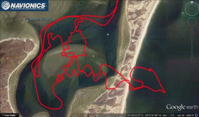
The ever-shifting sands of Monomoy at the elbow of Cape Cod made a major move this past March when winter storm Nemo re-opened the Chatham Southway, a channel separating South Beach from South Monomoy Island. Now, newly released maps from Navionics will help boaters navigate the ever-evolving channel.
Boaters have been keeping an eye on the widening cut and its shifting channels and sandbars, hoping that it will once again offer a shortcut from Nantucket Sound to the Atlantic Ocean’s popular striper and tuna grounds. Since 2006, when a Thanksgiving Storm filled in the Southway Channel for the first time in more than 40 years, the long, uninterrupted barrier beach has forced boaters to swing 9 miles south to go around the tip of South Monomoy.
Electronic charting company Navionics has begun sharing up-to-date maps of the Southway Channel through their Freshest Data program, which utilizes User Generated Content to deliver regularly updated chart data and corrections made by the more than one million customers that comprise the Navionics community.
According to posts on the Navionics Facebook page, Navionics employee Shaun Ruge has been making data-collection trips through the new cut. “This has proven to be a good test of the Navionics SonarCharts System,” wrote Ruge. “I, and any user with Sonar will contribute additional tracks here to keep on top of the changes.”
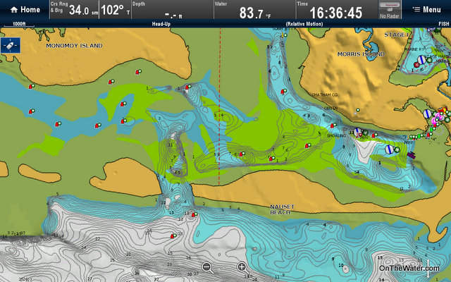

Thanks! This is something ANYONE can do to help other boaters, and yourselves. SonarCharts lets you upload recordings from most devices that are used in a crowd sourced, community augmented chart that is freely downloadable through navionics web site to active users of Freshest Data.
We are currently looking for Raymarine users to beta test software to upload their logs as well. I will offer free chart updates for those that help. email me at sruge@navionics.com to get involved in the Beta testing.