Cleveland Ledge’s Rocky Bottom And Tidal Flow Makes This Location Attractive To Bottom Fish

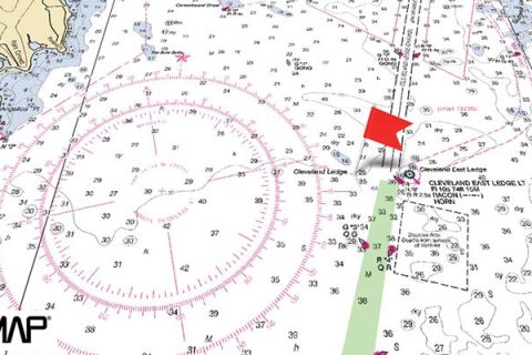
Located in Buzzards Bay at the beginning of the shipping channel that leads into the Cape Cod Canal, Cleveland Ledge is a popular bottom-fishing location. There are two main areas to the Ledge that can be productive. Cleveland East Ledge is on the east side of the shipping channel, and the Cleveland Ledge Light sits here. Across the channel to the northwest about a half-mile away is Cleveland Ledge proper, a shoal area 16 feet deep running in a southeast/northwest direction for about 300 yards.

What makes either location attractive to bottom fish is the rocky bottom and good tidal flow toward and from the Cape Cod Canal. In the spring, this is one of the most popular tautog fishing areas in Buzzards Bay. The rocky areas on top of the ledge get most of the attention for tautog fishermen (circled on the above map). Using your electronics to pinpoint areas with the craggiest structure and anchoring directly over them will give you the edge over other boats in the area when it comes catching tautog.

As the season progresses, popular areas on top of the ledge can get fished out, and it will pay off to use your maps to seek out un-fished areas. Slightly deeper water away from the main ledge that is marked with the “R” symbol indicating rocky hard bottom, like the areas marked with arrows on the above map, are worth investigating. You could find your own personal honey hole.

Scup, sea bass, and fluke fishing in the area can also be fantastic. Use your fishfinder to locate schools of scup and sea bass, which will often be chasing bait just off the bottom, and take advantage of your chartplotter to narrow down and repeat productive drifts.
Fluke are often found on the softer bottom in 20 to 30 feet that surrounds the ledges. When the predominant southwest breeze is blowing, drifts for fluke and sea bass are easiest when the tide is rising and the current is running into the Cape Cod Canal. This situation allows boaters to drift areas like the ones marked with dashed lines in the map above.
Although most people go to Cleveland Ledge to anchor and bottom fish, in the summer you’ll often find bluefish over the shoals and casting a popping plug around the base of the lighthouse can be very effective. Sometimes it’s possible to intercept one of the fast moving schools of false albacore that invade Buzzards Bay in the late summer and in the fall.
Keep a sharp eye out for boat traffic because large ocean-going vessels pass close by the lighthouse on their way to and from the canal. This is especially important anytime there is restricted visibility; be sure to anchor up well away from the channel.
The ledge area and the lighthouse itself were named in honor of President Grover Cleveland, who spent summers in the nearby Gray Gables area of Bourne and was an avid angler. President Cleveland frequently fished the area around where the lighthouse stands.
Can anyone tell me about cleavland ledge. Just wondering on tog fishing.